Saturday, 23 March 2013

Selun snow shoes tour

This weekend all my ski touring "colleagues" are not available...and this is not good. At least I could get a full day of off piste skiing on Friday. There was some fresh snow (probably the last of the season) plus a lot of some...hence me and a friend thought to take a day off and go skiing. It was a really good way to practice my off piste technique! Anyway...back to Selun.
   Being alone I did not feel like going ski touring on my own. I'm still not exceptionally good off piste and in case something happens I would be on my own trying to get down the mountain. Therefore I decided to go with snow shoes. Not as much fun maybe but at least I can keep my legs trained and I can still enjoy a day in the snow and with possibly some sun. With public transport I get at the beginning of the climb at 8:35, which is a decent time to start in this season. Starting point is Starkenbach, which not more than a small camping place, a few houses and a restaurant. I'm surprised by the amount of people I see at the beginning, a lot also with snow shoes. 
   Setting off properly takes longer than expected. I have to stop every 5 minutes to take off layer after layer because it is rather warm. At the end my conclusion was that the baselayer I choose was too warm...dressing for going to the mountains is really an art! However, with only the base layer on, and no gloves the temperature was OK. 
   On the way up all the memories from the very first ski touring trip came up. I did the same route already in December as my very first ski tour...and that was almost a disaster since I did not manage to put two turns together without falling...but that's another story. Snow conditions at the beginning don't look that good, rather icy and hard. However, after a couple of hundred meters the snow becomes much better...to the point I start regretting not having taken my skis! The path winds up close to the (closed) cable car and quickly goes into the woods, where the track becomes rather narrow. Up to this point I tried to make my own tracks in order to avoid "ruining" the ski tourers ones. But in the forest this is not possible anymore and I have to walk on the same tracks. That's not so bad because the snow has been very well compacted and there is not much to sink anymore. 
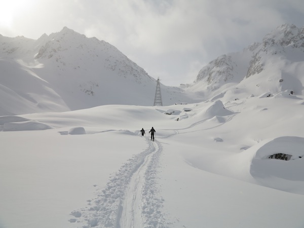
   After a bit more than 1 hour I get out of the woods and reach a small hut with a big aerial close to it. Here  I stop for a break. Views are really nice even though the sky is not completely clear. I'm quite astonished of the amount of people I see skinning up already...they must have started at least 1 hour before me. I even see a person skiing down already!!! Either he did not go to the summit, or he started really early....or he is fitter than Kilian Jornet :).

One of the first view of the summit

   From here on the track goes rather flat(ish) through some spare trees up to the beginning of the last (long) slope. From here I get to see the effect of the wind of the previous days. On the left side (compared to my view point) of the summit slope there are massive snow cornices...that massive that they should probably be defined as terraces :). My plan for the day was to try and attempt (depending on conditions) another summit. This summit stands to the left of Selun and has a very steep part (up to 50°) close to the top. Therefore I had my ice axe and crampons with me. The sight of these massive cornices made me think that there could be some snow cumulated on the route up (there is a small couloir to climb where the wind would have blown in). Also, in the forest I saw the typical sun balls rolling down the hills on their own. Therefore I judged the avalanche risk too high for attempting alone a 40° to 50° steep slope....hence Selun becomes the target of the day.


To the right Selun and to the left (first on the left) the other route that I wanted to try

I finally reach the final (even though very long) summit slope. I manage to overtake some ski tourers but I quickly realize how much easier it would be to skin up with my skis rather that walking with snow shoes. At some point on the way up I even find very good powder...and then I totally regret not having my skis. 


Quite a good training ground for skiing


The sun comes out and I stop for a minute just to appreciate the wonderful feeling of the sun shining on my face. At the same time I realize I forgot to put the sun cream on...but that only means I will have a very stron suntan for the next few days. I also remark what a good decision it was to go to the mountains even if on my own and on a known route. It's a real pleasure to just be out here and appreciate the nature and there is no other place I'd like to be. 
   Since I left the woods I always made my own tracks in the snow...but now this starts becoming rather difficult as I start sinking and several times sliding back...but I don't want to give up. All of a sudden all the people I saw going up already an hour ago start to come down. Some really good skiers I have to say...and one of them is even having a dog following him! Step after step and turn after turn I finally stand on the summit, 1330 meters higher than where I started. The view from up here is really great...despite the clouds covering a good part of it. But it does not matter that much in the end. I just came up here today because I wanted to enjoy a day out, spend some time in the nature, away from the clutter of the city. Sitting on my rucksack on the summit, while eating some chocolate and dried mango gives me a sense of relaxation that lying at home on the sofa would have never given me.


View towards Chur, Walensee in the bottom


View towards North


View directly down on the South side...rather steep!


Another view towards North, from a bit further along the summit ridge


Another view towards South...highlighting the scenic ridge of summits above the Walensee

   After some food and some pictures I start heading back to the valley...knowing that this time it will take surely longer than usual because I don't have skis. And as soon as I start going down I realize how much easier it would have been with the skis. Snow shoes are sliding all over the place and finding a good foot hold is not always easy. It's not that steep, maybe 30° but I think that doing it with skis would have been so much easier...and faster. After a while I start remembering how to go down on snow shoes and the descent becomes much faster. One I get again in the forest it becomes a little bit boring because I have to follow the foot path and taking short cuts would be too steep. Skiers on the way down seem to fly on the foot path...and it takes me a good two hours to make it all the way down. But anyway, is probably better like this. I feel much safer on the snow shoes...since this is only my first season of ski touring I thought that going alone would have not been a great idea. 
   

Saturday, 2 March 2013

Piz Lagrev skitour

Last weekend the plan was to go to St. Moritz to enjoy the nice ski resort. However, this was planned already last autumn (yes, you need that much time to reserve a youth hostel for 6 people :) )...and in the meanwhile I got into ski touring. Weather for the weekend looked absolutely incredible...far too good to just up and down on prepared pistes. That's why I decided to go on a ski tour. Close to St. Moritz there are loads of options but for some reason my choice falls on Piz Lagrev, a nice just above 3000m summit close to Silvaplana. 

Valley before the car park


First part of the ascent from the car park


First "jump" with rocks to the right

The official ski route starts along the road of the Julier Pass, which is open in winter but with no bus connection. Unfortunately me and my friend don't have a car so we have to ski all the way up from Silvaplana. This turned out to be the most difficult part of the tour. At the beginning there is not any snow on the road and on the summer foot path...so we have to walk. Finally we find some snow and we can put the skis on...but the fun does not last long. We find ourselves probably missing the path (somehow) and having to complete a really long traverse on the right side of the valley (having Silvaplan in the back). The traverse by itself would not be tricky, but considering the really icy snow and the rocks and the plant...things are not so easy as forecasted. In several occasions we actually have to literally walk on the grass with the skis. I'm sure my skins did not like that!
Finally, after 2 hours of approach, we reach the car park that is the official starting point of the ski tour. There is someone that like us has just started the climb...but this does not make me feel much better. I have the fear that is already late and that we won't probably make it to the real summit. In the meanwhile it got seriously hot, to the point that I did not have my gloves for even for a minute during the climb. And...oops, I also forgot the sun cream....


After the first jump - I
After the first jump - II


After the first jump - III


On the way up we finally find some shade that relieves us from the heat of the shining sun. Also the snows seems to be in much better conditions. The route simply follows the valley up to a first small plateau. Here, the route continues to the left, turning around and then above some shear rocks and ice. Probably this is the steepest part of the tour, not counting the one just below the summit. After this first "jump" the route continues to the right, slowly winding up to another plateau. From here it is possible to see the summit already and the hundreds of ski tracks of people that have summited Piz Lagrev during the week. 


Contouring around and around


...and around...


We take now a long round to the left, trying to keep the height instead of going down and then straight up again. This long round goes around the rock faces that are delimiting the valley and then joins the almost perfect slope that comes down from the summit. Here we start zig-zagging up to the top. Just before getting to the col there is one rather steep traverse (last zag of the zig-zag). This is however not a problem since lots of people have already made a good track before us. Once reached the col the summit is almost in sight. A few more turns and the summit is finally reached. To be honest, we reached only the ski summit...the official summit is still probably 1 hour away (there and back) along an almost flat ridge. However, it's already 12:45 and we decide that to avoid avalanche risk (wet avalanche) we are going to go back directly. Also, from the car park on the road down to Silvaplana we have no idea of how long it is going to take...so it's better to keep some time reserve. 


The summit!


People on the ridge, aiming to the middle summit
Views from the summit are magnificent. Sky is perfectly clear and there is absolutely no wind. I stay the whole time on the summit without gloves (even taking my skins off) and it feels really warm...maybe too warm. Surprisingly the summit is really crowded...especially of Italians. Some of them made it a bit further along the ridge but since none had ice axe or crampons nobody went to the real summit. We have all the equipment...but time has the last word and we have to go back. After a few pictures and the usual hand shaking we put the ski in ski mode and ski down. 
The descent is really good...powdery snow and hard only in small places. Unfortunately the fun ends when we reach the car park. At this point we have to follow the road back to Silvaplana. We try to follow the road on the side, always staying on the snow...but this snow is totally rotten, brown from the mud and surely not nice to ski. However, somehow, and after taking the skis off a couple of times...we manage to reach Silvaplana. Not a complete summit, but who cares...a perfect day on the ski!

Sunday, 10 February 2013

Cristallina ski tour…only to the hut unfortunately

This post comes a bit late compared to the trip date...but better late than never :). For two times I (and two friends) have attempted to climb Piz Cristallina in Ticino. First time was in summer 2 years ago and last time was last winter, with snowshoes. Both times we failed, even though in summer we at least managed to reach the ridge...but in a difficult spot. This year we wanted to try again, but on the skis. We set off in the morning from Baden in 4 people, two skiers and two snowboarders. The snowboarders have a splitboard...but none of them has ever used it before. No worries, I have a heavy down jacket to make sure I don't freeze to death while waiting for them to fiddling with the board(s). Around 9:30 we get to Ossasco, which is the typical starting point for trips to Cristallina. Weather is not that good as it is a bit cloudy and slightly snowing...but still good enough to ski up. I'm surprised to see the amount of people in the car park. It will be a busy hut tonight! Skins on, ARTVA checked, there we go! First part of the ascent simply follows the foot path through the forest. It's very nice to ski this up, but the thought of having to ski this down does not appeal to me at all. Rather narrow, very narrow and lots of trees around. OK, I love nature, but I don't want to hug a tree while skiing down :). The splitboarder show some difficulties where it becomes a bit steeper, but that is also because one of them has never used climbing skins, and the other has not used them for many years. Slowly slowly we make our way through the woods. When the forest starts to give way to the valley (Val Torta) and the angle eases a bit, it's possible to go out of the track and make a new one. Not for anything, but for the pleasure of listening to the sound of snow as it compresses under my skis. On the way up, after the forest, we basically follow the valley on the left hand side (looking from the top of the valley). Path is never difficult and never too steep. Only, sometimes the traverses might be slightly steeper, and there the splitboards are suffering...Going up we take the chance to practice some kickturns, since we are going to need them the day after.


 Finally the ski starts to clear a little bit and we get the sun to warm up our faces. Problem is that also the wind is picking up, and on average it gets slightly colder. When the valley turns right the paths flattens out a lot, and it's not only gentle up and downs. This does not look that good to be skied down tomorrow, especially for snowboards...but there is no problem as we will not come down this way. Last steep bit to the hut takes longer than expected. One of the splitboarders has not hiked a single meter for more than 1 year...so he feels all the effort. But despite his lack of training he does really well.

  IMG 0047

   IMG 0048  


 Finally, we get to the hut! Now I probably am a bit mean, but I "force" all my friends to go out again and do some avalanche rescue practice. It was cold, very cold, and the hands got frozen rather quickly. But it does not matter. Two of them never did this before and they must have at least an idea of that. After this we can finally get in the hut, warm up, eat and drink something. The hut is surprisingly full for being winter...but tomorrow should be a very good day according to the forecast, so it's understandable. At the table with us is sitting a group of Italians, so there is a lot of talking going on :). It's always good to find people from your own country when abroad. During the evening I discuss with some other people and they tell me that looking at the face of Cristallina it does not look very good. There is not enough snow for skiing (both up and down). Also, some tried the summit in the morning but failed because of too few snow...despite some still made it to the top. However, since none of us, except me, had crampons and ice axe (and the other skier did not even have the ski crampons!!) we decide not to attempt the summit on the day after. So this will be the third time I come to the Cristallina hut to attempt the Cristallina peak...and not make it. Well, nevermind, there will be a fourth time.

  IMG 0054


   IMG 0059


   IMG 0057

Morning after there a much better day waiting for us. Rather cold in the morning, but the totally clear sky makes you forget everything and just push to go out and ski. Even if we don't try the summit at least we try a different way skiing down to the valley. Following the ski route 13b and 521d we ski up to Passo della Cima di Lago. From there a nice powdery descent on the Ghiacciaio di Valleggia. Waiting for the split boarders is not that nice because in the glacier is still in the shadow...and that's not so warm :). Put the skins back on and skin up to the following pass. Here I meet another ski tourer that seems to be a pro. He has ridiculously light skis and binding and it's quite funny to see how he skis down. For sure he can't get much stability out of his skis, but on the other hand he hiked up all that we are going to ski down in an astonishingly short time! Finally take the skins off for the last time and then let the skis go until the valley! The descent is quite nice, snow is already tracked out but the conditions are still good enough. Another nice ski touring trip. Again no summit...but an alpinist should know: summit is an option, going back is a must!

Saturday, 26 January 2013

Leckihorn ski tour

A few weeks ago I finally got my new (and first) ski touring skis...so the need to try them properly has been there since. Last weekend I was out with the SAC but due to the bad weather we did not ski that much. For this weekend the weather forecast looked really nice, especially in the centre of Switzerland. The choice of the tour went on the Leckihorn, a just above 3000 (3068m) peak above the valley of Realp. Plan is the following. Leave straight after work on Firday, ski a bit uphill and find a nice place to camp with a tent. Start then early in the morning, leaving all the camping stuff buried somewhere and then go up and down in a single day. Sounds good...off we go!
   We arrive in Realp at 19:00 on Friday evening. To our surprise an almost full moon is shining really bright in the ski, and thanks to the reflection of all the white snow, we don't even have to turn the head lights on. The path follows the river on the right hand side (seen from Realp) until a small wooden bridge. The bridge is right under another bridge, which is the one of the road leading to the furka pass, now obviously closed. The paths is relatively wide and it winds up the hill until a few alps (typical houses/farms in the swiss mountains). Close to one of those we decide to put up camp. In a short time the tent is set and the cooking is on going. Once we stop moving and start eating the cold starts to pick up. One thermometer we have with us signs -17°C, but it probably a couple of degrees off. Still pretty cold. Views from the camp are amazing. Thanks to the moon we can see the full valley and right in the middle the few lights of Realp shine like candles. Really, really beautiful.
   Morning after the alarm goes off at 5:30. Due to some issues with frozen stuff, especially contact lenses, we end up being able to set off only at 7:00. Not too bad. We see some lights walking up the path and we realize there must be other ski tourers coming up. Skiing up is a real pleasure. The tips of the mountains getting the first sun light and slowly turning from blue, to orange and then to white.


Short after sunrise


From time to time it is cold, and the stops are kept down to a minimum. Soon we are overtaken by two ski tourers and then by a group of people all with the dynafit ski set, and racing binding. Even though I'm tempted, there is no point in trying to keep up with them :). The path up is even marked at the beginning, where a sing distinguishes between winter and summer path. Nice one. We follow the Witenwasserental until we reach Oberstafel (ski route 90). Then we turn right following the route 970b aiming to the Rotondo hütte.


The sun starts hitting the valley


My new skis


The hut is there!

Until now the path has never been really steep, but the short section before the Rotondo hut is quite steep...and coupling this with the fact that the sun finally started shining on us, it got quite hot. Once we reach the hut two of the guys we met in the morning tell us that inside they offer a really nice cake. So, why not. We are not in a rush (or at least we still don't think we are in a rush) so we stop at the hut to get something to eat. Something...I should say, a lot! The piece of cake we are presented with is absolutely massive, really, never seen such a big piece of cake. But for sure we are hungry and we don't complain :). After 20 minutes of break we start again heading to the Leckipass.
   My ski touring colleague was walking up with the snowshoes and he was walking in the ski tourer track, after me. Naturally, this was a bomb waiting to explode and in fact it did. Soon after leaving the hut we are overtaken by two ski tourers and one of them starts complaining a lot about the fact that my friend is "destroying" the ski tracks with the snowshoes. Come on man, you are outdoor and in the wilderness...if you expect to come out here and to find a nicely prepared track for you, then you have probably chosen the wrong sport. I agree that the nice "rails" created by skiers are a bit broken be the snowshoes. But anyway, the snowshoes don't sink a lot because the track is already quite compacted. Moreover,you (the ski tourer) did not pay for the tracks so please DO NOT complain. Also, the snowshoer is even carrying the snowboard on his back, so he is making a bigger effort than you. How could you ask him to make his own new tracks in the fresh snow? Why don't you go and make your own track, lazy skier?? I've to admit we get a bit fired up discussing with this guy...I would not expect to meet such people in the mountain. Anyway, we switch in such a way that I walk after the snowshoes and try to re-set the ski track. 
   Soon the terrain gets steeper and we (well, I) have to start doing more and more kick turns. We finally reach the Leckipass and we get a nice view on the glacier underneath...it looks like a perfect run. But we still have a job to do, the summit is not yet conquered. A few more kick turns and we reach the so called ski depot. Crampons take the place of the skis, rucksack are left together with the ski, and we start walking up. In a really short time we finally reach the summit. OK, to be fair we only reach the cross, the summit is a couple of meters higher. It would be possible to reach the summit, but it looks a bit sketchy and without a rope we don't dare attempting it...as nobody else did.


The real summit...not so nice without rope


The absolutely perfect glacier


Pizzo Rotondo


Somewhere in the distance the Finsteraarhorn


View from to summit down on the ski depot


   Views from the summit are amazing. From the Weisshorn to the Finsteraarhorn, and of course the much closer PIzzo Rotondo. A few pictures and there we go. Back to the ski depot the ski come back on, boots in ski mode and the descent starts. The glacier is the absolute total perfection. Not so steep, powder snow and basically no tracks at all. However, the fun does not last that long. We ski down along the 980a route. The plan is then to go up again to catch the 980c route which will then bring us to the place where we left the tent, which is somewhere close to Laubgädem. Problem is that nobody has been on this route before us. So we have to make the fresh tracks all the way up (just below 400m). It's not that much but the legs are already tired and the uphill in the fresh and soft snow it's not really easy. 
   Once we reach what we think is the top we take the skins off and start skiing. Unfortunately the terrain becomes basically flat or gently going up and down. We end up literally dragging ourself for  good two hours until we can finally meet the proper route (lots of ski tracks). We even meet a couple of relatively old people that where following us from the glacier. They assumed that we knew the route...:). Well, in fact we did know it, but we just took it from a bit lower than we should have and therefore we had to contour along on flat until we reached the route again. At this point the sun was already gone for a while and it start becoming dark. In the end we reach the camping spot with the head torches on since it was completely dark. 5 minutes to put all the stuff back in the rucksack and we sky down the road in the complete dark, with the head torch. Finally, and I really mean it, finally, we reach the town after a 12 hours ski tour. 
   What a day! I did not really enjoy the part in which I had to drag myself along, that is true. But that is the so called category 2 fun. Looking back at it, it was nice, but avoiding that flat section would have been much better. Still, a very very good workout. My intentions of going skiing (on piste) the next day vanished very quickly...and I spent a relaxing day at home :).

Friday, 28 December 2012

Monte Amaro in invernale con pernotto al bivacco pelino

Come ormai da tradizione quando torno in Italia dalla Svizzera si organizza una qualche gita in montagna...che tipicamente riserva sempre qualche sorpresa. Questa volta, a causa della spalla lussata di mio fratello, non si poteva organizzare nulla di tecnicamente impegnativo. Per cui, si é deciso di andare sul Monte Amaro, pernottare al bivacco pelino a due passi dalla cima, e poi scendere il giorno dopo. Motivazione principale é stata il voler testare il sacco a pelo invernale nuovo di zecca di mio fratello.
   La mattina del 27 Dicembre di parte da Bari alle 4:00. Dopo essersi fermati a Campo di Giove per noleggiare due paia di ciaspole si va fino a Passo San Leonardo e li' si lasciano le macchine. Alle 9:30 ci si mette in cammino. Siamo in 5, uno dei quali non ha mai messo piede sulla neve con le racchette...per cui non si procede troppo velocemente. Per fortuna la giornata é davvero stupenda ed é un piacere passeggiare sulla neve.


Dopo circa un'ora di cammino si giunge ai piedi del canalone della direttissima. Abbiamo scelto di percorrere questa via all'andata e di scendere poi passando dai piani di femmina morta e fonte dell'orso. Il canalone sembra meno ripido di quanto sembrava dal parcheggio di Passo San Leonardo. Di solito é sempre cosi', le montagne sembrano sempre piu' ripide quando viste di fronte e da lontano...di solito!


La salita lungo il canalone procede inizialmente senza problemi, anche se un paio di membri del gruppo hanno dei problemi alle gambe. Il caldo inizia a farsi sentire...Incontriamo tre sci alpinisti che si fermano a circa un terzo del canalone perché non hanno i ramponi per gli sci e ritengono che la neve piu' in alto sia gelata. La cosa un po' mi preoccupa perché le ciaspole che abbiamo non sono del tutto adatte a percorrere grosse pendenze su neve gelata.


La salita comincia a rivelarsi sempre piu' impegnativa e le ciaspole hanno sempre meno aderenza. Ci fermiamo in un punto in cui la neve soffice permetteva di scavare un gradino per sedersi. Vista la difficoltà a procedere con le racchette da neve, si decide di provare ad andare avanti senza racchette da neve. Dopo un piccolo test mi accorgo che con un po' di sforzo si riesce a calciare gradini nella neve che danno molta piu' sicurezza delle racchette da neve in precario equilibrio. L'unico piccolo problema é che io sono l'unico ad avere scarponi adatti a questo mestiere, ovvero procedere su un pendio innevato calciando gradini nella neve. Quindi io sono costretto ad andare avanti tutto il tempo per i rimanenti (quasi) 600m di canalone.


Inizialmente si procede bene e anche molto piu' velocemente che con le racchette...ma poi la neve fresca comincia ad aumentare e si sprofonda abbastanza. La stanchezza aumenta velocemente ma il sole si fa sempre piu' basso all'orizzonte per cui non c'é tempo da perdere. Il canalone diventa anche sempre piu' ripido...Per fortuna la neve fresca si concentra tutta al centro del canalone, per cui scegliendo accuratamente il percorso é possibile evitare in gran parte di sprofondare nella neve. 
   Poco prima dell'uscita del canalone, che si raggiunge voltando a destra una volta sotto i salti di roccia che scendono direttamente dal punto piu' alto, la neve si fa molto dura. Io con i miei scarponi riesco a calciare piccoli gradini laterali che mi sono sufficienti per un decente equilibrio. Visto che pero' gli altri non hanno scarponi altrettanto rigidi sono costretto a scavare piccoli gradini con l'aiuto della piccozza. La pendenza non é elevata, anzi é molto minore del canalone e quindi questo lavoro non é pericoloso, né troppo faticoso. Finalmente si esce dal canalone, con il sole ormai quasi a filo dell'orizzonte. Lo spettacolo é stupendo ma questa volta non ho la mia macchina fotografica DSLR, solo una piccola compatta e quindi le foto non renderebbero giustizia. Personalmente ero convinto che il bivacco fosse praticamente a due passi...ma in realtà eravamo ancora circa 150 metri sotto la cima. Il modo piu' sicuro per arrivare in cima sarebbe stato di fare un bel giro attorno ad una "parete" di circa 40° di pendenza...ma il tempo non ce lo permetteva. Per cui, ho continuato il mio lavoro di calcia e scava anche su questo pendio. Quando cominciavo quasi a perdere le speranze perché il sole era ormai del tutto tramontato e il freddo si stava facendo sentire, la croce di vetta fa capolino e allora siamo sicuri di essere praticamente a due passi dal bivacco. Entriamo nel bivacco dopo il tramonto, ma per fortuna grazie ai riflessi della neve a un po' anche grazie alla luna piena si vede ancora molto bene.


Il bivacco é piu' ospitale di come me lo aspettassi, anche se dentro c'é parecchia neve...probabilmente qualcuno si é dimenticato la porta aperta. Dopo una cena abbastanza veloce si va a dormire visto che tra la sveglia alle 3:15 e le 8 ore di cammino le energie rimaste non sono poi tante.
   Durante la notte la temperatura non va di molto sotto lo zero, nel bivacco. Le bottiglie d'acqua non ghiacciano del tutto e la condensa che si forma sul soffitto cade come goccia d'acqua. Grazie al mio sacco a pelo da -27° passo una notte molto calda...tranne che per quei due minuti in cui sono dovuto uscire per andare in bagno :).
   Il vento infuriava per tutta la notte, ma questo era il meno. La mattina dopo, ci rendiamo conto che non si vede a un passo a causa della nebbia. Questo, oltre al freddo pungente (la percepita sarà stata intorno ai -15°) ci fa un po' preoccupare. Per fortuna abbiamo un piccolo navigatore GPS da montagna con salvato l'itinerario di discesa. Lo seguiamo fedelmente. La via di discesa é ad ogni modo abbastanza ovvia in quanto ci troviamo su una grossa cresta (molto larga) che va seguita. Su entrambi i lati é troppo ripido. Dopo una mezzoretta di cammino il vento comincia a calare e ogni tanto la nebbia si dirada regalando dei bei panorami.


Una volta entrati nella valle sotto femmina morta la nebbia svanisce del tutto, ma resta il vento. L'ultimo ostacolo per la discesa si presenta alla fine di questa valle. Ci troviamo su punto piu' alto di una enorme conca che dobbiamo percorrere per tornare alla strada. I primo 100 metri sono abbastanza ripidi ma per fortuna la neve é buona e permette una buona aderenza con le racchette. I successivi 300-400m sono meno ripidi e grazie alla neve soffice si riesce a scendere senza molta fatica e anche molto velocemente.


Arrivati alla fine di questa conca non resta che seguire delle tracce si sci alpinisti attraverso il bosco, facendo quasi a botte con i mille rametti che sbattevano in faccia. Alle 13:30, finalmente, si raggiunge la strada. Tolte le racchette si cammina sulla strada fino a tornare a Passo San Leonardo, chiudendo cosi' un anello da 22Km. 
   Una cosa buffa é che quando torniamo al negozio dove abbiamo noleggiato le racchette, il negoziante ci dice che non credeva ci avrebbe visto mai piu'! Dalle domande che ci fa intuiamo che lui non conoscesse nessuno che avesse fatto la stessa cosa di inverno, forse solo gente salita e scesa in giornata. Comunque, per lo spettacolo che si gode dalla cima e per la sensazione di solitudine che si gode da lassu', consiglio questa gita a tutti. Un consiglio, in inverno i ramponi e la piccozza possono tornare molto molto utili. Se noi li avessimo avuti avremmo fatto molta meno fatica e saremmo stati anche molto piu' sicuri.