This year I think I have found the definition of holiday...alpine climbing all the time...this time with my brother. The plan is pretty simple. Take a car (we had to rent one) and a tent and set somewhere in the valley next to some nice big mountain waiting for good weather. Despite the weather has been rather bad the whole summer, we got quite lucky with the weather so there was not much sitting around.
Saturday 23.08
First objective is the south ridge of the Weissmiess, a route which I already did two years ago, but it was good to get my brother used to alpine routes. We start in Saas Almagell and walk up all the way to the hut...no chance we were going to take a cable car. The hut is suprisingly full, to the point that two turns have to be organized for dinner. I have to say it is not so much fun to go in the mountains when there are so many people around...but this is an easy and famous route, plus the forecast for Sunday is good.
Sunday 24.08 - Weissmiess from the South Ridge - PD+ 4023m
In the morning there are so many people outside the hut like I've never seen before, but at least there is no risk of getting lost. From the hut the route follows the path up to the pass, which I find is a good way to either wake up or warm up before the "real stuff" begins. Up on the pass is rather cold, and the wind is really strong. After traversing a bit to the left we need to put on crampons, harness and rope up. At this point my fingers get really cold because of the wind but best approach is not to think to much about it and start to get going as soon as possible to get warm again. There are people everywhere...and everyone seem to take his/her own track. We decide to zig-zag up the snow field until a "flat" part of the ridge with few rocks. Once up here the wind has gone down a little and due to the physical effort it feels a little bit warmer too. Take off the crampons because not much snow on the ridge and start walking up. Climbing up on the ridge is very easy and fun, maximum II. But because of so many people it's a bit of a mess. People are trying to overtake at any single moment, and even passing in between your legs if you don't pay attention. Also it's not really possible to stop to take a rest without stopping dozens of people. Route finding is not that difficult.
Finally though we reach the snowy part of the ridge and here the ridge gets a bit larger and we can take a good break for putting on crampons. From this point onwards the route is again very easy even though the snowy ridge might be a little bit thin in places...but it depends on what you are used to...if you believe this one is thin than you probably need some more experience :).
Getting to the top, even if the route is easy, is always a good feeling...especially if it's a 4000m summit. The summit plateau is very busy and the normal route on the west face looks like a pilgrimage of people. But in this case that's probably good news since the path will be really well trodden. In less than one hour we reach the bottom, after having basically run in the lower part to avoid the danger of the overhanging seracs.
Monday 25.08 - Lagginhorn from the South Ridge - AD- 4010m
After the warm up trip it's time to do something a little bit more "serious". The weather for the day is not looking really awesome, but not that bad...so we give it a try. From the Hohsaas restaurant we start walking directly towards east and then towards north in direction of point 3329. We don't follow the path under the small ridge that goes up to the 3329 point, but instead follow the snow field which is a little bit longer but much easier to find the way. From point 3329 we traverse at an approximately constant height on the Hohlauggletscher until the Lagginjoch. Once on the ridge the good fun starts. It's still rather cold, but not that bad. In the initial part the climbing is rather easy and the route is not that difficult to find. In some places there are friends stuck into cracks...you never know whether to trust this things, but at least they indicate what could be the right way.
Things start to get a little bit more tricky on the first steep part of the ridge, where we have to start traversing to the left before going up. Once again, bunches of rope loops are a good indication that we are on the correct route. After the first steep part of the ridge we reach the point where one of the west ridges is joining the south one. Here things start to get a little but more tricky because the amount of snow is considerable. Crampons have to get back on our boots and they will stay there for the rest of the route.
Finding the route is never difficult, but good care is recommended in some places due to ice and snow. Weather starts also to deteriorate and could close in...not that fun anymore I must say. The route however is always quite easy to find as it's always on the ridge. Towards the end there is one section where the ridge goes down again towards a small saddle. Here there is one bolt at the top of a 3a slab from which abseiling is possible. This is located on the right side of the ridge (looking towards the top). I preferred to lower the other two and then downclimb the slab. A fall would have probably been fatal because is more than 20m downclimimbing...but it felt pretty safe. Once on the saddle you have to shortly downclimb once again (always on the right hand side) and then traverse using some fixed ropes until the other side of the saddle. From here onwards the ridge goes up rather steeply and then almost flat until the end. Before the end it is advisable to go to the left before climbing up.
View from the summit should be amazing as always...but we are wrapped inside the clouds and apart from the summit cross there is little else to see.
Descent is from the normal route which follows the west ridge. The rather high amount of snow makes the descent a bit easier because it's all tracked quite well. Once back on the rocks the route should be really easy with some short sections of downclimbing. Unfortunately it started raining on the way down and this made all the rocks incredibly slippery. So also the way down takes longer than expected until we finally reach the snowfield at the bottom of the west face. From here onwards we traverse on the Lagginhorngletcher aiming for the point 3123 and the marked footpath that leads directly yo Hohsaas. An incredibly long day, in quite bad conditions...but still a good day out.
Wednesday 27.08 - Hike up to Rothornhut
The plan for 27 and 28 was originally to try the Obergabelhorn or the Zinalrothorn. But we changed our mind and decided to go only for the Wellenkuppe, which is still above 4000m, but a much shorter climb compared to the other two. The hike up to the Rothorn hut starts in Zermatt, from the city centre. It's probably one of the longest hut approach that I have ever done, but quite nice indeed. There are two restaurants on the way, and in the middle the path gets much more gentle and almost flat, allowing for some "rest". However, the last part up the moraine is really killing the legs and the feet...but hey, we are not here to have fun, are we??
Thursday 28.08 - Ober and Unter Aeschhorn
Weather forecast for today are very good but once outside the hut after breakfast it's snowing and we even see some thunders in the distance. This is very similar to what I saw last summer before attempting the Matterhorn, and that time I had to climb back because of bad weather on the route. Not willing to make the same mistake twice I decide not to trust the weather forecast and to aim for a different objective, the Aeschhorn. Those are two little summits not that far from the hut and most of the route is on a rather flat glacier. Therefore a retreat in case of bad weather would be quite easy. We first aim for point 3550 on the saddle between the two Aeschhorn summit, then to the Ober first. This route allows for some interesting climb at the beginning and then it's all scrambling on relatively easy terrain. We climb back along the ridge and then follow the snow ridge to the summit of the Unter. At this point during the day the weather has prefectly cleared and the view is simply magnificent...absolutely stunning.
What to say, the weather forecast were correct and we "wasted" a good chance for another 4000m summit. But nevertheless it was a nice day with quite relaxed climbing and wonderful views.
Saturday 30.08 - Hike up to the Mischable hut
The plan for the next two days is to attempt the Nadelhorn from the normal route. So the starting point is the Mischable hut. I thought the hike up to the Rothorn hut was the tough one...but this one...is a real killer. From the centre of Saas Fee we follow the sign posts and we reach the hut in a rather fast time, 3h 15m including breaks. But this foot path is really a tough one. Steep, steep and again steep from the beginning until the end with never a single break. And towards the end there is even a sort of via ferrata that makes things a bit more interesting. Once at the hut we feel like having reached another 4000m summit, so tough it was to walk up. Weather is not looking very good. Clouds surround everything and it's not looking like it will get any better...let's see what happens in the morning.

Sunday 31.08 - Nadelhorn normal route - PD+ 4327m
In the morning the weather is in fact not that good, and very cold and windy. Well who cares, until the beginning of the ridge the route is really easy to find and does not present that many problems so we decide to start and see what happens during the day. The route follows the ridge until point 3620 and then veers right on the glacier. Once on the glacier the route keeps a rather constant height until under the slope that leads up to the Windjoch. This slope can be easily overcome by two or three zig-zags. As the guidebook says, the windjoch is really wind and here it feels really cold. But the weather still seems quite good and we decide to keep on going. From this point onwards the route simply follows the ridge until the summit, and getting lost is basically impossible, aslo because it's all quite tracked. the conditions however look like winter rather than end of summer.
Until the very last bit of the ridge there are almost no rocks as it's all covered in snow. And even on the last section where we expected to climb a little bit on rocks it's all still covered in snow. It's not so hard this snow and it does not feel very safe, especially because there are many people on the same route and if someone slips it can be quite critical. However, slowly progressing on very short and tight rope we finally manage to reach the last short and almost flat section of the ridge. And there we are, on the summit of the third 4000m summit in this week. Views are again magnificent even though mostly covered in clouds. The Dom looks absolutely immense seen from here.
All the excitement and the adrenaline are not enough to cope with the very cold temperatures. And seeing all the people still aiming for the summit along the normal route we decide to quickly turn back down and get to safety. Downclimbing the first sections of the ridge on steep soft snow is not that much fun, especially because of too many people going upo and down at the same time. But in a short time we are again on the glacier and then on the ridge back to the hut.
This was an incredible week. A total of 3 4000m summits plus two little ones in between. I lost approximately 5 kg in this week even though we kept eating a lot...and this says a lot on the level of effort and how cold it was. The original plan was to attempt the Matterhorn and also other more technical routes, but technical skills of someone and bad conditions on the mountains forces us to change the plans. Nevertheless, fun, excitement, adreanaline and magnificent views were all the ingredients of this good 9 days in the Alps.
Saturday 23.08
First objective is the south ridge of the Weissmiess, a route which I already did two years ago, but it was good to get my brother used to alpine routes. We start in Saas Almagell and walk up all the way to the hut...no chance we were going to take a cable car. The hut is suprisingly full, to the point that two turns have to be organized for dinner. I have to say it is not so much fun to go in the mountains when there are so many people around...but this is an easy and famous route, plus the forecast for Sunday is good.
 |
| View from the hut, Allalinhorn in the middle |
Sunday 24.08 - Weissmiess from the South Ridge - PD+ 4023m
In the morning there are so many people outside the hut like I've never seen before, but at least there is no risk of getting lost. From the hut the route follows the path up to the pass, which I find is a good way to either wake up or warm up before the "real stuff" begins. Up on the pass is rather cold, and the wind is really strong. After traversing a bit to the left we need to put on crampons, harness and rope up. At this point my fingers get really cold because of the wind but best approach is not to think to much about it and start to get going as soon as possible to get warm again. There are people everywhere...and everyone seem to take his/her own track. We decide to zig-zag up the snow field until a "flat" part of the ridge with few rocks. Once up here the wind has gone down a little and due to the physical effort it feels a little bit warmer too. Take off the crampons because not much snow on the ridge and start walking up. Climbing up on the ridge is very easy and fun, maximum II. But because of so many people it's a bit of a mess. People are trying to overtake at any single moment, and even passing in between your legs if you don't pay attention. Also it's not really possible to stop to take a rest without stopping dozens of people. Route finding is not that difficult.
Finally though we reach the snowy part of the ridge and here the ridge gets a bit larger and we can take a good break for putting on crampons. From this point onwards the route is again very easy even though the snowy ridge might be a little bit thin in places...but it depends on what you are used to...if you believe this one is thin than you probably need some more experience :).
Getting to the top, even if the route is easy, is always a good feeling...especially if it's a 4000m summit. The summit plateau is very busy and the normal route on the west face looks like a pilgrimage of people. But in this case that's probably good news since the path will be really well trodden. In less than one hour we reach the bottom, after having basically run in the lower part to avoid the danger of the overhanging seracs.
 |
| At the beginning of the ridge |
 |
| Somewhere on the ridge |
 |
| Last part of the snowy ridge |
 |
| My brother on his first 4000m summit! |
 |
| On the way down, looking at tomorrow's objective |
 |
| Looking back at the way down...quite windy up there |
Monday 25.08 - Lagginhorn from the South Ridge - AD- 4010m
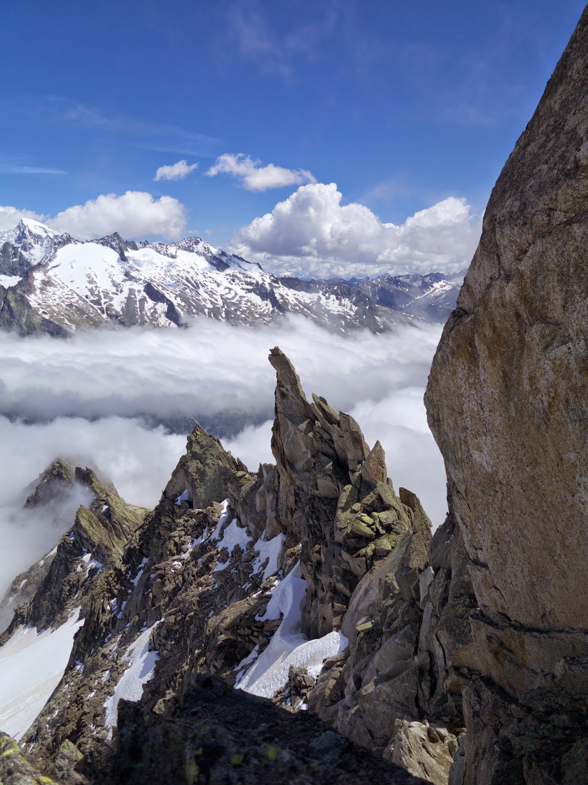
After the warm up trip it's time to do something a little bit more "serious". The weather for the day is not looking really awesome, but not that bad...so we give it a try. From the Hohsaas restaurant we start walking directly towards east and then towards north in direction of point 3329. We don't follow the path under the small ridge that goes up to the 3329 point, but instead follow the snow field which is a little bit longer but much easier to find the way. From point 3329 we traverse at an approximately constant height on the Hohlauggletscher until the Lagginjoch. Once on the ridge the good fun starts. It's still rather cold, but not that bad. In the initial part the climbing is rather easy and the route is not that difficult to find. In some places there are friends stuck into cracks...you never know whether to trust this things, but at least they indicate what could be the right way.
Things start to get a little bit more tricky on the first steep part of the ridge, where we have to start traversing to the left before going up. Once again, bunches of rope loops are a good indication that we are on the correct route. After the first steep part of the ridge we reach the point where one of the west ridges is joining the south one. Here things start to get a little but more tricky because the amount of snow is considerable. Crampons have to get back on our boots and they will stay there for the rest of the route.
Finding the route is never difficult, but good care is recommended in some places due to ice and snow. Weather starts also to deteriorate and could close in...not that fun anymore I must say. The route however is always quite easy to find as it's always on the ridge. Towards the end there is one section where the ridge goes down again towards a small saddle. Here there is one bolt at the top of a 3a slab from which abseiling is possible. This is located on the right side of the ridge (looking towards the top). I preferred to lower the other two and then downclimb the slab. A fall would have probably been fatal because is more than 20m downclimimbing...but it felt pretty safe. Once on the saddle you have to shortly downclimb once again (always on the right hand side) and then traverse using some fixed ropes until the other side of the saddle. From here onwards the ridge goes up rather steeply and then almost flat until the end. Before the end it is advisable to go to the left before climbing up.
View from the summit should be amazing as always...but we are wrapped inside the clouds and apart from the summit cross there is little else to see.
Descent is from the normal route which follows the west ridge. The rather high amount of snow makes the descent a bit easier because it's all tracked quite well. Once back on the rocks the route should be really easy with some short sections of downclimbing. Unfortunately it started raining on the way down and this made all the rocks incredibly slippery. So also the way down takes longer than expected until we finally reach the snowfield at the bottom of the west face. From here onwards we traverse on the Lagginhorngletcher aiming for the point 3123 and the marked footpath that leads directly yo Hohsaas. An incredibly long day, in quite bad conditions...but still a good day out.
 |
| On the first part of the ridge |
 |
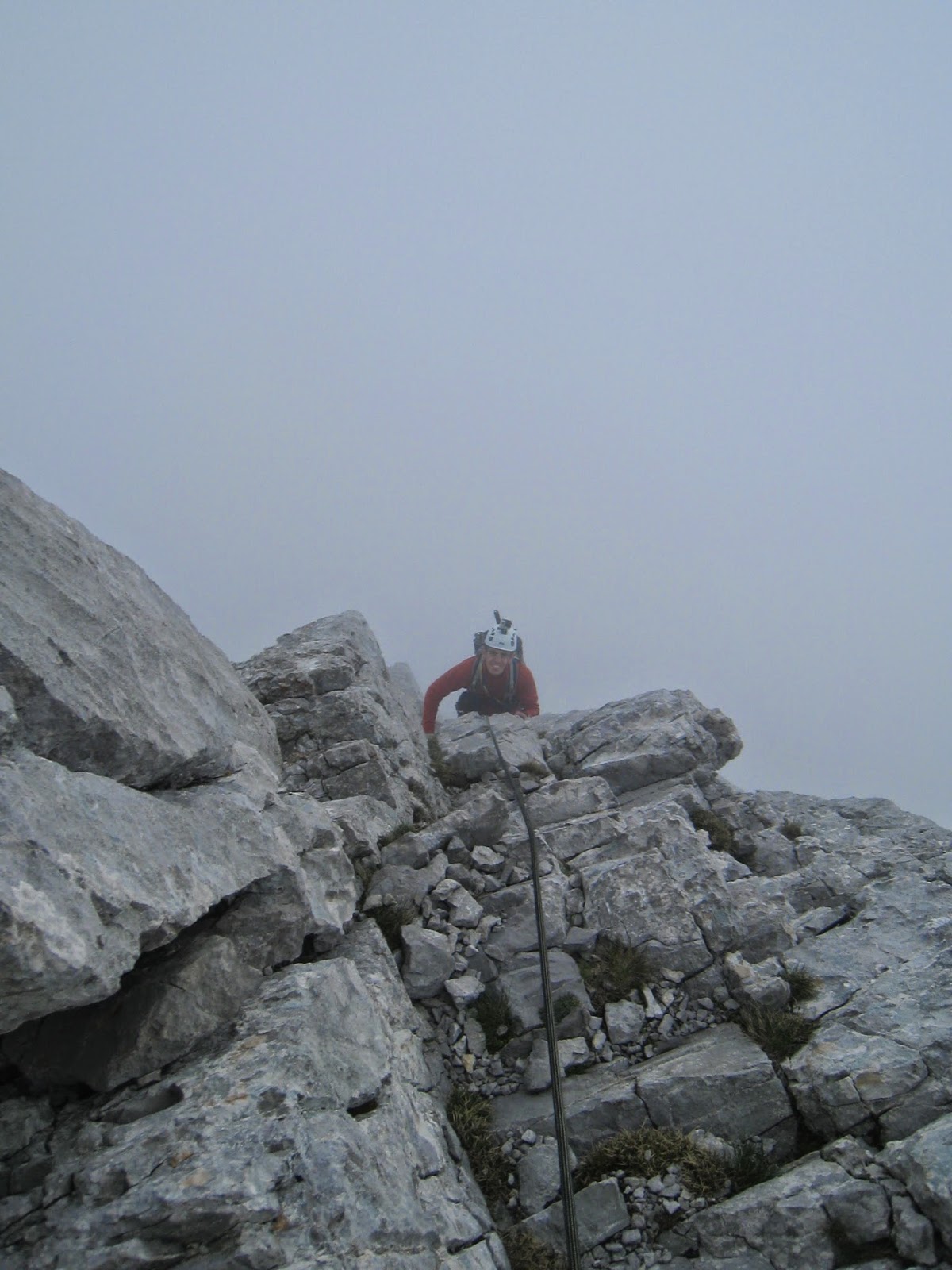
| Still having fun |
 |
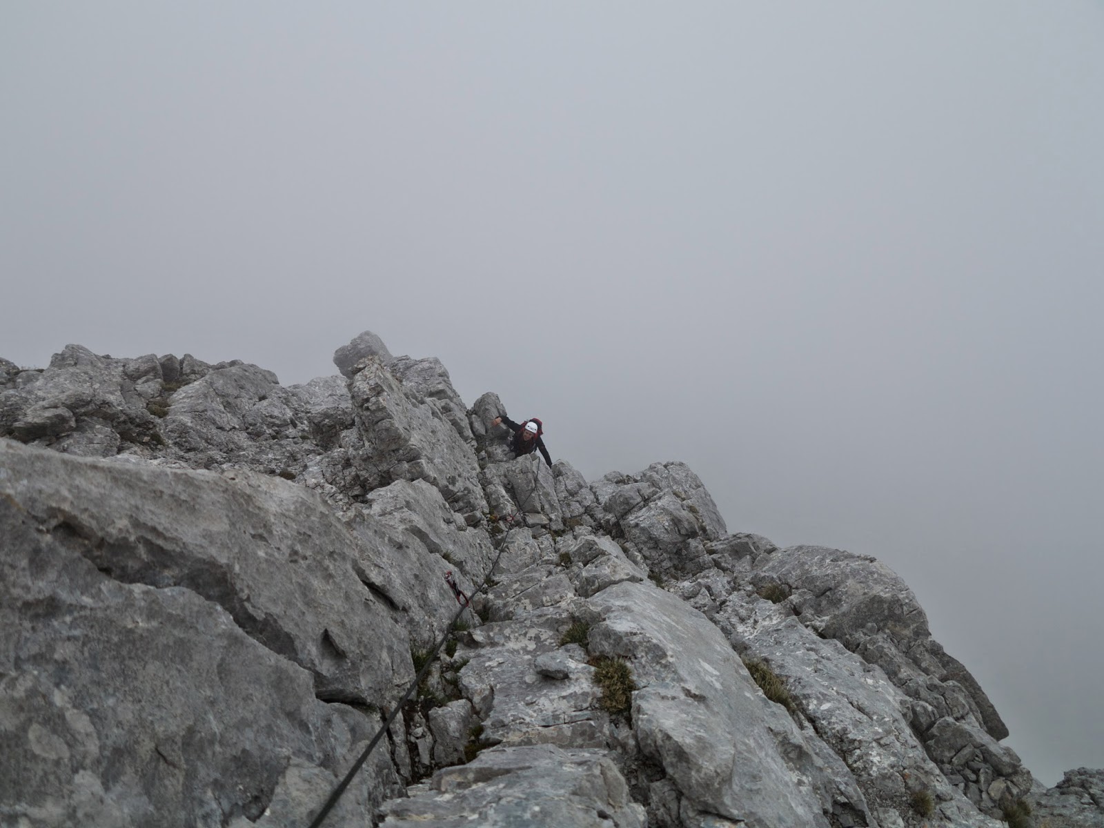
| Somewhere higher...cold starts to kick in |
 |
| Hang on...is this summer or winter?? |
Wednesday 27.08 - Hike up to Rothornhut
The plan for 27 and 28 was originally to try the Obergabelhorn or the Zinalrothorn. But we changed our mind and decided to go only for the Wellenkuppe, which is still above 4000m, but a much shorter climb compared to the other two. The hike up to the Rothorn hut starts in Zermatt, from the city centre. It's probably one of the longest hut approach that I have ever done, but quite nice indeed. There are two restaurants on the way, and in the middle the path gets much more gentle and almost flat, allowing for some "rest". However, the last part up the moraine is really killing the legs and the feet...but hey, we are not here to have fun, are we??
 |
| Hotel Trft, more or less half way up the hut |
 |
| Well...this is a view |
Thursday 28.08 - Ober and Unter Aeschhorn
Weather forecast for today are very good but once outside the hut after breakfast it's snowing and we even see some thunders in the distance. This is very similar to what I saw last summer before attempting the Matterhorn, and that time I had to climb back because of bad weather on the route. Not willing to make the same mistake twice I decide not to trust the weather forecast and to aim for a different objective, the Aeschhorn. Those are two little summits not that far from the hut and most of the route is on a rather flat glacier. Therefore a retreat in case of bad weather would be quite easy. We first aim for point 3550 on the saddle between the two Aeschhorn summit, then to the Ober first. This route allows for some interesting climb at the beginning and then it's all scrambling on relatively easy terrain. We climb back along the ridge and then follow the snow ridge to the summit of the Unter. At this point during the day the weather has prefectly cleared and the view is simply magnificent...absolutely stunning.
What to say, the weather forecast were correct and we "wasted" a good chance for another 4000m summit. But nevertheless it was a nice day with quite relaxed climbing and wonderful views.
 |
| View from the Ober Aeschhorn, just before the clouds vanish |
 |
| Ridge to the Unter Aeschhorn |
 |
| Poetic? |
 |
| The ridge towards the Unter Aeschhorn |
 |
| Stunning! |
Saturday 30.08 - Hike up to the Mischable hut
The plan for the next two days is to attempt the Nadelhorn from the normal route. So the starting point is the Mischable hut. I thought the hike up to the Rothorn hut was the tough one...but this one...is a real killer. From the centre of Saas Fee we follow the sign posts and we reach the hut in a rather fast time, 3h 15m including breaks. But this foot path is really a tough one. Steep, steep and again steep from the beginning until the end with never a single break. And towards the end there is even a sort of via ferrata that makes things a bit more interesting. Once at the hut we feel like having reached another 4000m summit, so tough it was to walk up. Weather is not looking very good. Clouds surround everything and it's not looking like it will get any better...let's see what happens in the morning.
Sunday 31.08 - Nadelhorn normal route - PD+ 4327m
In the morning the weather is in fact not that good, and very cold and windy. Well who cares, until the beginning of the ridge the route is really easy to find and does not present that many problems so we decide to start and see what happens during the day. The route follows the ridge until point 3620 and then veers right on the glacier. Once on the glacier the route keeps a rather constant height until under the slope that leads up to the Windjoch. This slope can be easily overcome by two or three zig-zags. As the guidebook says, the windjoch is really wind and here it feels really cold. But the weather still seems quite good and we decide to keep on going. From this point onwards the route simply follows the ridge until the summit, and getting lost is basically impossible, aslo because it's all quite tracked. the conditions however look like winter rather than end of summer.
Until the very last bit of the ridge there are almost no rocks as it's all covered in snow. And even on the last section where we expected to climb a little bit on rocks it's all still covered in snow. It's not so hard this snow and it does not feel very safe, especially because there are many people on the same route and if someone slips it can be quite critical. However, slowly progressing on very short and tight rope we finally manage to reach the last short and almost flat section of the ridge. And there we are, on the summit of the third 4000m summit in this week. Views are again magnificent even though mostly covered in clouds. The Dom looks absolutely immense seen from here.
All the excitement and the adrenaline are not enough to cope with the very cold temperatures. And seeing all the people still aiming for the summit along the normal route we decide to quickly turn back down and get to safety. Downclimbing the first sections of the ridge on steep soft snow is not that much fun, especially because of too many people going upo and down at the same time. But in a short time we are again on the glacier and then on the ridge back to the hut.
 |
| On the top!! |
 |
| The magnificent Dom |
 |
| Looking back at the ridge |
 |
| The Lenzspitze north face |
This was an incredible week. A total of 3 4000m summits plus two little ones in between. I lost approximately 5 kg in this week even though we kept eating a lot...and this says a lot on the level of effort and how cold it was. The original plan was to attempt the Matterhorn and also other more technical routes, but technical skills of someone and bad conditions on the mountains forces us to change the plans. Nevertheless, fun, excitement, adreanaline and magnificent views were all the ingredients of this good 9 days in the Alps.